Capital Weather Gang's Jason Samenow explains the three different directions Irma could take and what areas would be impacted. (Claritza Jimenez/The Washington Post)
(This story will be updated throughout Friday. It was last updated to incorporate the 11 p.m. National Hurricane Center advisory as well as new model information, suggesting Florida’s west coast is most at risk.)
The extraordinarily large and intense Hurricane Irma is drawing ever closer to South Florida. A hurricane catastrophe has become nearly unavoidable; it’s only a matter of what areas are hardest hit and how severely.
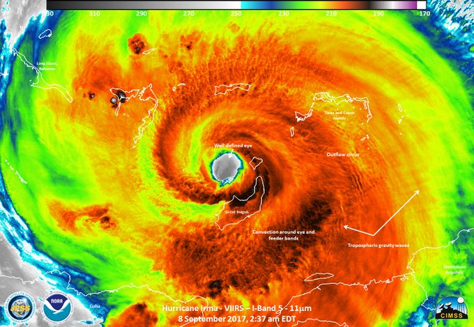
Friday night, it regained Category 5 intensity, packing 160 mph winds, just before making landfall on the Camaguey Archipelago of Cuba. It is the first Category 5 hurricane to make landfall in Cuba since 1924.
Irma is comparable in strength to Hurricane Andrew, which devastated parts of South Florida in 1992, but much larger in size.
Based on the latest projections, it’s almost impossible the storm will miss. Computer model information late Friday afternoon and evening suggested a track up Florida’s west coast was becoming most likely, though shifts were possible. The Florida Keys, Naples, Fort Myers, and Tampa, could all be severely impacted although the Hurricane Center said “it is extremely difficult to pinpoint exactly where the center might move onshore.”
Irrespective of the storm’s exact track, hurricane-force winds could blast most if not all of the Florida peninsula.
“Irma is likely to make landfall in Florida as a dangerous major hurricane, and will bring life-threatening wind impacts to much of the state regardless of the exact track of the center,” the National Hurricane Center said.
The Hurricane Center had hoisted hurricane warnings for much of South and Central Florida on both coasts. Hurricane watches extended somewhat further north on both sides of the peninsula.
Landfall from the storm is most likely to occur sometime between Sunday morning and afternoon, when Irma’s most destructive winds will move ashore.
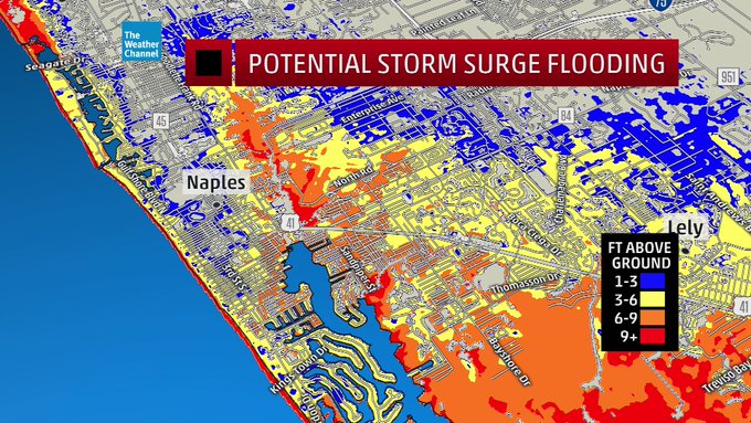
A storm-surge warning was also issued for much of the South and Central Florida coastline because of the potential for water to rise up to 6 to 12 feet above normally dry land at the coast. The Hurricane Center said this would bring the risk of “dangerous” and “life-threatening” inundation and that the threat was highest along Florida’s southwest coast.
“Few people alive have experienced a storm like this,” wrote Bryan Norcross, a hurricane specialist at Weather Channel. “It is reminiscent of the great hurricanes that unleashed their fury on Florida in the first seven decades of the 20th Century.”
By early next week, Georgia and the Carolinas could also be in the storm’s crosshairs.
Hurricane Irma, the most potent Atlantic Ocean hurricane ever recorded, is expected to make landfall in South Florida over the weekend. Mar-a-Lago, President Trump's waterfront golf club, evacuated ahead of the storm. (Reuters)
In its 11 p.m. update, the storm was positioned 300 miles south-southeast of Miami and chugging along to the west at 13 mph.
With the eye of the storm moving over the north coast of Cuba, its circulation could become disrupted by the land mass which could lead to some weakening. However, once it moves back over the water some of the warmest in the world(nearly 90 degrees), it could restrengthen.
The Hurricane Center said to expect fluctuations in the storm’s intensity through Sunday but that, in most scenarios, “Irma is expected to remain at least a Category 4 hurricane until landfall in Florida.”
It urged residents of Florida to rush preparations to completion.
“This hurricane is as serious as any I have seen,” tweeted Eric Blake, a forecaster at the Hurricane Center. “No hype, just the hard facts. Take every life saving precaution you can.”
Meanwhile, Hurricane Katia made landfall along in Mexico’s Gulf Coast Friday evening. And on Saturday, Hurricane Jose, which was nearly a Category 5, could hit some of the same small islands in the northern Lesser Antilles ravaged by Irma, including Antigua and Barbuda. Hurricane warnings were in effect.
Potential effects on Florida
Several storm scenarios are possible in Florida, depending on the exact track Irma takes, but they are all disastrous due to Irma’s size and strength.
Hurricane-force winds expand 70 miles from the center, and tropical-storm-force winds expand 185 miles from the center. This implies that the entire peninsula, which is about 150 miles across, will be exposed to tropical-storm-force winds and most or all of it to hurricane-force winds.
Norcross, the meteorologist who became a hero in South Florida for guiding the region through Hurricane Andrew, called the threat “EXTREME.”
Tropical-storm-force winds are expected to reach South Florida by Saturday morning as Irma approaches from the southeast.
Then, the all-important northward turn is still expected to take place early Sunday, when the storm would make landfall and unleash its worst effects. The most destructive winds and largest storm surge usually focus immediately to the northeast of where the center comes ashore. So exactly where the northward turn occurs is a critical question for Florida.
As of Friday evening, the most likely scenario based on computer-model guidance was that the storm will track along or just inland of Florida’s west coast – with landfall closest to Florida’s southwestern-most tip.

Group of simulations from American (blue) and European (red) computer models from Friday morning. Each color strand represents a different model simulation with slight tweaks to initial conditions. Note that the strands are clustered together where the forecast track is most confident but they diverge where the course of the storm is less certain. The bold red line is the average of all of the European model simulations, while the blue is the average of all the American model simulations.(StormVistaWxModels.com)
Models, however, can shift. The difference between a track just off the east coast and just off the west coast is only 150 miles, and the average error in hurricane forecasts 36 hours before landfall is about 50 (or one-third of the width of the peninsula). Irma could still reasonably track closer to the east coast.
If the storm buzz-saws up the west coast, then Key West, Naples, Fort Myers, Tampa and Tallahassee would face severe effects – and this scenario was becoming more likely. If it runs up the spine of the peninsula, the storm will be quicker to decay, but hurricane-force winds would reach both coasts. Least likely, perhaps, if the storm tracks closer to Florida’s east coast, then Miami, Fort Lauderdale, West Palm Beach, Melbourne, Daytona Beach and Jacksonville will take devastating hits.

The European and American model forecasts run Friday morning show the storm making landfall near the southwest tip of Florida midday Sunday, and then coming up the spine of Florida. Model shifts are still possible. (WeatherBell.com)
When Irma makes its closest approach to Florida — most likely early Sunday — the Hurricane Center predicts that it will produce Category 4 winds. Here is its description of the kind of damage Category 4 winds would inflict:
Catastrophic damage will occur: Well-built framed homes can sustain severe damage with loss of most of the roof structure and/or some exterior walls. Most trees will be snapped or uprooted and power poles downed. Fallen trees and power poles will isolate residential areas. Power outages will last weeks to possibly months. Most of the area will be uninhabitable for weeks or months.
Note that such extreme winds are typically confined to the eye wall, which is only about 10 to 15 miles wide. That is why the exact track is important in terms of where the most severe wind damage concentrates.
It’s important to note that wind speeds will increase with altitude, so high-rise buildings will be exposed to even stronger winds, up to a hurricane category stronger on the upper floors.
Due to the likelihood of widespread damaging winds, one model run by researchers at several universities projects that more than 2.5 million customers in Florida and the Southeastern United States will lose power.
“Peak power outages for Hurricane Harvey were between 300,000 and 400,000, so this is many times larger than that,” said Seth Guikema, a researcher at the University of Michigan leading this modeling effort
Regardless of exactly where Irma tracks, many coastal population centers in Florida will experience a devastating storm surge of 6 to 12 feet above normally dry land, inundating roads, homes and businesses. The most severe storm surge will focus immediately north-northeast of where the storm center crosses land – which could be near the southwest tip of Florida and then along Florida’s west coast, including Marco Island, Naples, Cape Coral, Ft. Myers, Port Charlotte, Sarasota, and up to Tampa, perhaps.
The Hurricane Center predicts all of the Florida Keys to see a storm surge of 5 to 10 feet. “It’s not clear that it’s a survivable situation for anybody that is still there in the Keys,” said Ed Rappaport, acting director of the National Hurricane Center in a television interview.
Over the Florida peninsula, 8 to 20 inches of rain is forecast, with the heaviest amounts most likely in the southeast.
Potential effects on Georgia and the Carolinas
Beyond Florida, there is a risk for damaging winds and a serious storm surge up to Georgia and the Carolinas, but the details greatly depend on the track over Florida.
If Irma rides up the spine of Florida, even though it will lose some strength, its circulation is enormous so it would still likely push a significant storm surge toward the Georgia and South Carolina coasts. Tropical-storm and even hurricane-force winds would also likely affect much of Georgia and perhaps sections of South Carolina (especially the south and southwest).
Even a track up the west coast of Florida would likely bring strong winds and some surge to the Georgia and South Carolina coasts.
The worst case for these states, which has become less likely, would be if Irma narrowly misses the east coast of Florida, stays over warm water and then hits them while maintaining its strength. A potential landfall along the Southeast coast would be Monday — and would bring a devastating storm surge and destructive winds to coastal locations.
In any of the scenarios, there is the likelihood of very heavy rain over much of Georgia and into the Carolinas, and areas of flash flooding.
Irma’s path so far
Thursday evening, the center of the storm passed very close to the Turks and Caicos, producing potentially catastrophic Category 5 winds. The storm surge was of particular concern, as the water had the potential to rise 16 to 20 feet above normally dry land in coastal sections north of the storm center, causing extreme inundation.
A devastating storm surge and destructive winds had also likely battered the southeastern Bahamas, near Great Inagua Island.
Through early Thursday, the storm had battered islands from Puerto Rico to the northern Lesser Antilles.
While the center of Irma passed just north of Puerto Rico late Wednesday, a wind gust of 63 mph was clocked in San Juan early Wednesday evening, and more than 900,000 people were reported to be without power. In Culebra, Puerto Rico, a small island 17 miles east of the mainland, a wind gust registered 111 mph in the afternoon.
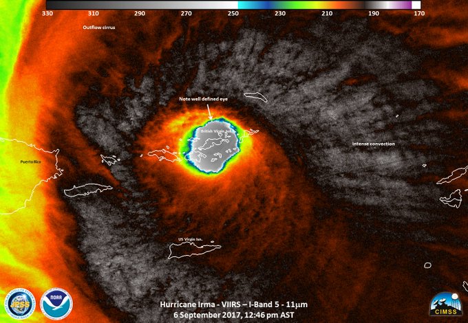
Wednesday afternoon, the storm’s eye had moved over Virgin Gorda in the British Virgin Islands, and its southern eye wall (the region of most powerful winds) raked St. Thomas in the U.S. Virgin Islands.
Early Wednesday afternoon, a wind gust to 131 mph was clocked on Buck Island and 87 mph on St. Thomas in the U.S. Virgin Islands.
Tuesday night and Wednesday morning, the hurricane passed directly over Barbuda and St. Martin in the northern Leeward Islands, the strongest hurricane ever recorded in that region and tied with the 1935 Florida Keys hurricane as the strongest Atlantic storm to strike land.
Gaston Browne, the prime minister of Antigua and Barbuda, toured the extensive damage caused by Hurricane Irma on Sept. 6. (ABS TV Antigua)
As Barbuda took a direct hit, the weather station there clocked a wind gust to 155 mph before it went offline.
The storm also passed directly over Anguilla and St. Martin early Wednesday, causing severe damage.
Irma’s place in history
Irma’s peak intensity (185 mph) ranks among the strongest in recorded history, exceeding the likes of Katrina, Andrew and Camille — whose winds peaked at 175 mph.
Among the most intense storms on record, it trails only Hurricane Allen in 1980, which had winds of 190 mph. It is tied for second-most intense with Hurricane Wilma in 2005, Hurricane Gilbert in 1988 and the 1935 Florida Keys hurricane.
The storm maintained maximum wind speeds of at least 180 mph for 37 hours, longer than any storm on Earth on record, passing Super Typhoon Haiyan, the previous record-holder (24 hours).
Late Tuesday, its pressure dropped to 914 millibars (the lower the pressure, the stronger the storm), ranking as the lowest of any storm on record outside the Caribbean and Gulf of Mexico in the Atlantic basin.
The storm has generated the most “accumulated cyclone energy,” a measure of a storm’s duration and intensity, of any hurricane on record.
Without a doubt, the World Meteorological Organization will retire the names Harvey and Irma after this season. While there have been several instances of consecutive storm names getting retired (Rita and Stan 2005, Ivan and Jeanne 2004, Isabel and Juan 2003, Luis and Marilyn 1995), the United States has been hit by more than one Category 4+ hurricane in a season only one time: 1915. Two Category 4 hurricanes hit in Texas and Louisiana six weeks apart that year.
Source read more


No comments:
Post a Comment